Urban Renaturalization Projects in Barcelona II
Barcelona Is Replacing Paved Areas Such as Intersections and Inner-Block Spaces With New Green Areas, Fostering Urban Ecological Regeneration

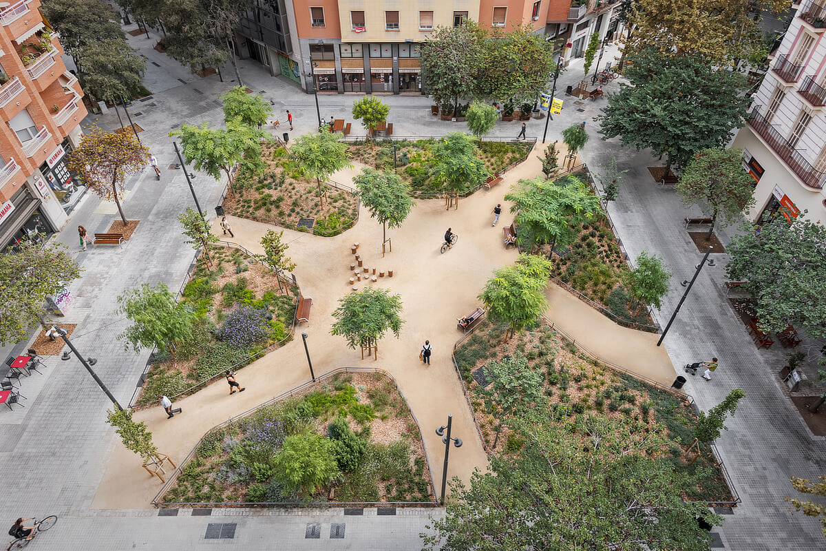
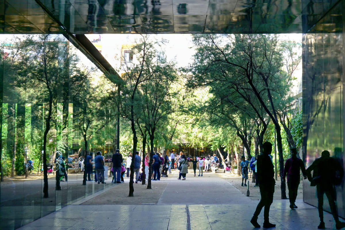
Plaça-jardí Rocafort by 08014 arquitectura, © Pol Viladoms
Barcelona: From Hard Plazas to Sustainable Parks
As discussed in the first part of the article “Urban Renaturalization in Barcelona”, Barcelona’s recent transformation reflects a paradigm shift that places nature and pedestrians at the heart of urban design, reclaiming spaces previously dedicated to traffic and embracing sustainable solutions. However, this emphasis on the natural component of public spaces was not always a priority in the Catalan capital.
In the years leading up to the 1992 Olympic Games, for example, the City Council opted to intervene in dense and, in some cases, run-down neighborhoods through so-called “hard plazas”: paved spaces that sought a balance between high-quality architectural design and low maintenance. These squares prioritized functionality and social cohesion over the presence of vegetation, and in those years, they became a hallmark of Barcelona.
Despite this trend, other projects more connected to nature were carried out alongside the hard plazas and could even be seen as forerunners of recent renaturalization trends. Examples include the Parc de la Creueta del Coll (1987) by Martorell, Bohigas, and Mackay, and the Parc del Nus de la Trinitat (1993) by Batlleiroig Arquitectura.
Plaça-jardí Rocafort, © Pol Viladoms
Renaturalizing the Cerdà Plan and Its Intersections
Over the past decade, Barcelona has been moving toward a more livable and ecologically integrated model through Green Axes, green roofs, and the reconfiguration of major infrastructure. In this context, the projects analyzed below share these principles, but they also fit specifically into the fabric of the Eixample district, reinterpreting its grid of city blocks and chamfers. Both the Green Axes and the spaces emerging at their intersections explore new ways of occupying and articulating this historic fabric, incorporating strategies for renaturalization, water management, and social activation that provide continuity and coherence to the proposed urban model.
Street intersections that still follow the layout of the Cerdà Plan have become a new focus of interest. As previously discussed in the blog dedicated to the Superblocks, the potential generated by the chamfers allows these intersections to be adapted as pedestrian areas. But while they were already spaces of great strategic value in the context of the Superblocks, the development of the Green Axes has enhanced their renaturalization, and they are increasingly being designed as parks rather than squares.
The emergence of these new green areas improves urban biodiversity and mitigates the heat island effect, something that is especially welcome in the Eixample neighborhood, traditionally one of the areas most affected by car traffic and the scarcity of natural spaces.
Plaça-jardí Rocafort, © Pol Viladoms
The Plaça Jardí Rocafort (2023) by 08014 arquitectura
Located at the intersection of the Consell de Cent and Rocafort Green Axes, Plaça Jardí Rocafort is a prime example of these new parks. To achieve the renaturalization of the space, the team at 08014 arquitectura, led by Adrià Guardiet and Sandra Torres, designed the project with objectives such as biodiversity, permeability, and accessibility in mind, dedicating 46% of the renovated area to green space.
Another key premise is the division of the space into two clearly distinct sectors. The central area is occupied by the park itself, featuring six irregularly shaped garden beds and six gravel paths that converge on a rest area characterized by a cluster of tree trunks serving as seats.
The perimeter, on the other hand, functions as an expanded sidewalk, maintaining its character as a transit zone. It is largely distinguished by its paving, consisting of concrete slabs and, in some places, old cobblestones recovered at the spot during the process of removing the asphalt.
The project adheres to SUDS (Sustainable Urban Drainage Systems) strategies through permeable paving and rainwater collection wells, while the selection of plant species seeks variety in various aspects such as height, color, stratum coverage, and flowering season.
Jardí Illa by LANDLAB Laboratorio de paisajes, © LANDLAB
The Jardí Illa (2023) by LANDLAB Laboratorio de paisajes
The Jardí Illa project, designed by the LANDLAB team, dates from the same year as the previous example, but was shaped by the unique circumstances of its location, at the intersection of Consell de Cent and Enric Granados. It is situated halfway between Plaça Letamendi and the University of Barcelona Gardens and thus helps to enhance a landscape axis of great historical and botanical interest, due to the diversity of species it harbors.
The space is organized with an asymmetrical design that alternates paths and irregularly shaped garden beds. The green elements are classified according to their function and characteristics into botanical gardens, with greater biodiversity; Mediterranean gardens, dominated by low-maintenance local species; and rain gardens, which play a more active role in restoring the natural water cycle.
In all cases, plant species have been chosen for their suitability to both the current and future environment, taking climate change into account. Species that may temporarily disappear or that bloom at different times have also been included, emphasizing the cycle of the seasons.
The project also incorporates solutions from the SUDS repertoire, such as tree pits, bioretention strips, floodable garden beds, and infiltration basins.
Jardí Illa in its urban context, © LANDLAB
Reinventing Cerdà’s Eixample Blocks
On another note, still linked to the legacy and evolution of the Eixample, it is worth recalling the labor of the municipal organization ProEixample, which, beginning in the 1980s, dedicated itself to revitalizing the neighborhood’s inner courtyards as parks and public spaces.
The spirit of this initiative sought to return to the origins of the Cerdà Plan with its aspirations for a garden city and was essentially aligned with more recent greening initiatives. Although the organization no longer exists, its legacy endures, and to date more than forty block centers have been converted, including the Montserrat Roig Gardens and the Cándida Pérez Gardens. The restoration process is somewhat slow and highly complex, but the results are very rewarding.
Jardins d’Interior d’Illa Càndida Pérez by RCR Arquitectes, © Vicente Zambrano González/Ajuntament de Barcelona, licensed under CC BY-NC-ND 4.0
The Isabel Vilà and Dolors Piera Plazas (2020) by the Institut Municipal d’Urbanisme
Although it is a rather unique case, the squares Isabel Vilà and Dolors Piera represent a variation on the interventions mentioned above. They are located on a block laid out according to the Cerdà Plan, but situated in the Poblenou neighborhood.
The partial and delayed development of the block allowed for a more comprehensive intervention within the framework of the 22@ project. New buildings were constructed on the flanks, and the public housing building by BAAS Arquitectura mentioned in the blog post “Social Housing in Barcelona’s Sant Martí District” was built in the center.
Once the building massing was redefined, an ambitious redevelopment of the open space was undertaken, resulting in what is known as the Isabel Vilà and Dolors Piera Plazas (2020), designed by the Municipal Institute of Urban Planning. Rather than squares in the traditional sense, these are two interconnected parks strongly linked to the surrounding streets through the opening of the chamfers.
As in other recent projects, the successful design of these spaces is largely based on the application of SUDS, notably the use of permeable paving and a series of ponds and wells designed to collect and reuse rainwater.
The proposal also includes paths, varying elevations, a long pergola with benches, urban vegetable patches, and lush vegetation that help create a small oasis in the heart of 22@.
Aerial view of Plaça de les Glòries in 2006, © Tavisa/Ajuntament de Barcelona, licensed under CC BY-NC-ND 4.0
The Plaça de Les Glòries: From a Failed Civic Epicenter to a Major Crossroads
One of the most emblematic examples of urban planning and landscaping in the new Barcelona is the Parc de les Glòries, and to understand its significance, a brief overview of the history of this space may prove enlightening.
As part of the Eixample project, Ildefons Cerdà conceived a plaza shaped like a tilted square at this strategic location where three major avenues intersected, destined to become the new symbolic and political center of Barcelona. But relocating the institutions to this site far from the historic city center, in an area that would take decades to develop, required an immense effort and a political will that no one was willing to assume.
By the time the city finally reached this area, the Plaça de les Glòries had become a residual space where vehicular traffic had taken over, although a few disconnected gardens had managed to squeeze in between the avenues and viaducts.
On the occasion of the 1992 Olympic Games, an attempt was made to bring order to this chaotic space that did little to live up to its name (Plaza of the Glories). An elevated elliptical viaduct was then built, which proved beneficial from the standpoint of traffic flow but left much to be desired from the perspective of pedestrians. The pseudo-square remained a barrier between the different neighborhoods that converged at this crossroads.
Aerial view of the redesigned Plaça de les Glòries in 2025, © DRONEIT/Ajuntament de Barcelona, licensed under CC BY-NC-ND 4.0
The Parc de les Glòries (2025) by Agence Ter and Ana Coello
Finally, around the year 2000, the City Council determined that a new project was necessary, but with a very different goal: rather than improving traffic flow, the aim would be to restore the urban fabric and renaturalize the public space. The relative scarcity of large green spaces in the city further tipped the scales towards this option: Les Glòries would be renovated as an urban park.
An international competition was then launched to transform this traffic hub into a predominantly green and pedestrian-friendly space. The results were announced in 2014, with first prize awarded to the team formed by Agence Ter and Ana Coello de Llobet. The proposal was radical in many respects, but due to various logistical circumstances, would not be completed until more than a decade later, in 2025.
Canòpia Urbana – Parc de les Glòries by Agence Ter and Ana Coello, © Fernando Lua
The first thing that catches the eye about the project is the solution adopted for the existing avenues. Both the Diagonal and the Meridiana avenues are completely closed to car traffic, serving solely as thoroughfares for pedestrians and bicycles. Only the Gran Vía maintains its continuity thanks to the construction of an ambitious tunnel that had to pass under the two train lines and one subway line located beneath the plaza.
This decision was made due to the significance of this avenue, which extends even beyond the metropolitan area: to the southwest, it connects to the airport, and to the northeast, to the highway leading to France.
The effects of these decisions are more than evident. The Parc de Les Glòries is now a haven of calm, while also fostering the interconnection of the surrounding neighborhoods.
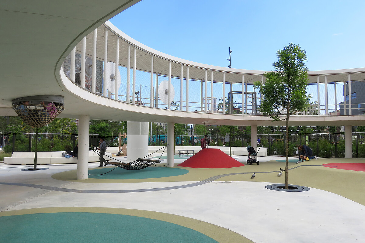
Children’s playground at Canòpia Urbana – Parc de les Glòries, © Fernando Lua
Biodiversity Nodes and the Gran Clariana
Another key aspect of the project was the creation of three distinct levels: an underground level devoted to services and transportation, a ground-level area for pedestrian use, and a third level defined as an “urban canopy,” formed by the tree tops.
In terms of landscape design, the park is structured around thematic nodes with biomorphic silhouettes, dedicated to topics such as sports, children’s playgrounds, dogs, and the promotion of biodiversity. Among these, the Gran Clariana (Great Clearing) stands out—a large expanse of grass that has quickly become a popular gathering spot for public leisure.
In the rest of the green areas, local tree species, shrubs, and plants with low water requirements predominate. The wild appearance of the garden beds reflects the goal of recreating microhabitats that encourage the proliferation of urban wildlife, and once again, SUDS strategies are integrated, helping to restore the natural water cycle.
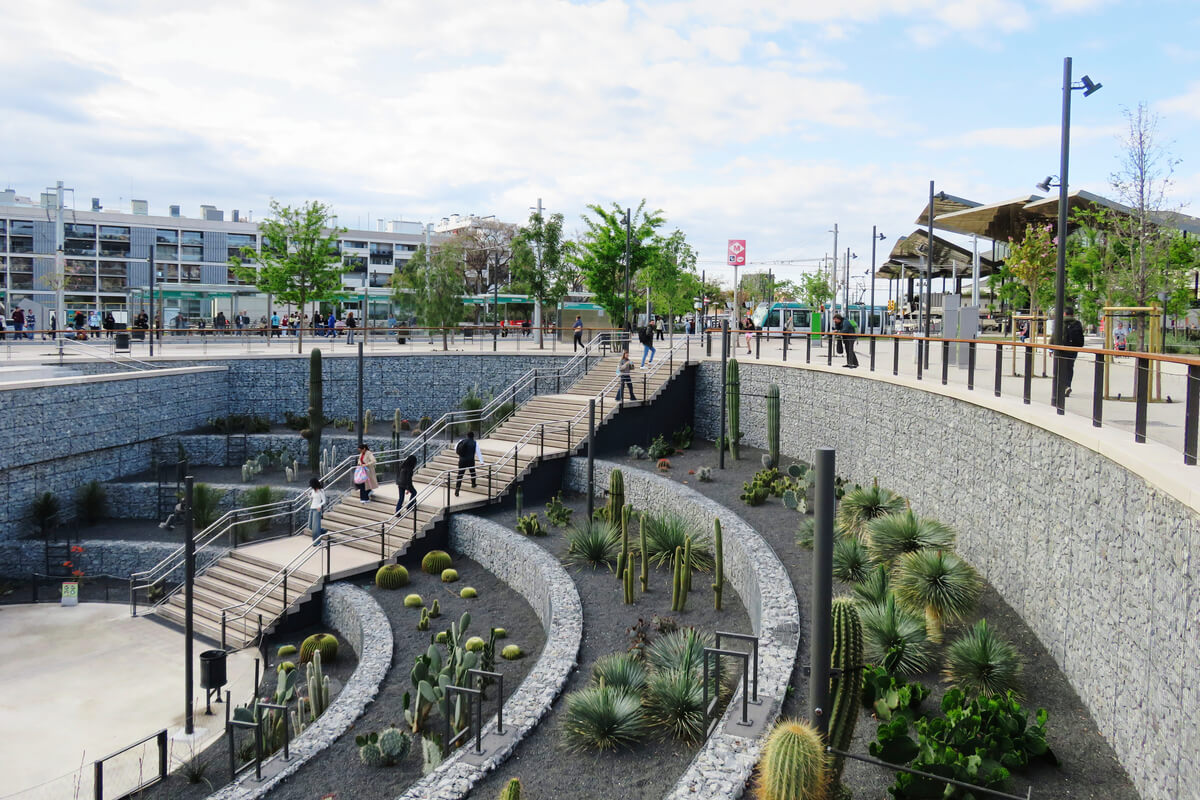
Cactus garden at Canòpia Urbana – Parc de les Glòries, © Fernando Lua
Renaturalization as an Urban Planning Project for Barcelona
The scale of the undertaking at Parc de les Glòries ensures a positive and significant impact on the process of renaturalizing the urban environment, making it one of the most ambitious projects on the path toward a more sustainable, livable, and socially cohesive Barcelona.
However, its most notable value lies in the fact that it is not an isolated initiative, but rather part of a broader, coherent urban strategy that coordinates efforts of different scales under the same principles. The park synthesizes many of the strategies developed in smaller-scale projects: the expansion of pedestrian space, the incorporation of sustainable drainage systems, the promotion of biodiversity, and adaptation to climate change.
Both the new garden squares in the Eixample and the revitalized inner courtyards, the Green Axes, and the large metropolitan parks form part of an interconnected network that reinforces the city’s resilience and livability.
This comprehensive approach multiplies the impact of each intervention and redefines Barcelona’s urban image, fostering a new dynamic between citizens, public space, and nature.
Text: Pedro Capriata
BIBLIOGRAPHY
08014 Arquitectura (s.f.). Plaça-Jardí Rocafort.
https://www.estudi08014.com/wordpress/?page_id=3993
ACPA Ana Coello (s.f.). Parque de las Glorias canopia urbana.
https://acpa.com.es/es/proyectos/parque-de-las-glorias-canopia-urbana/
Ajuntament de Barcelona (2018). Urbanització a la Plaça Dolors Piera i la Plaça Isabel Vila.
https://ajuntament.barcelona.cat/santmarti/sites/default/files/plenari/fitxers/urbanitzacio_pl._dolors_piera.pdf
Ajuntament de Barcelona (2021). Guia Tècnica per al disseny de sistemas de drenatge urbà sostenible.
https://share.google/rXwfQ6CXfzm6a8rq5
Ajuntament de Barcelona (2021). Pla Natura Barcelona 2021-2030.
https://share.google/BjbNIzFKnAlB5zkk5
Batlleiroig (2022). Fusionando Ciudad y Naturaleza. Actar.
Capriata, P. (2023). Las Supermanzanas y los ejes verdes de Barcelona, un modelo de ciudad más sostenible. Guiding Architects Barcelona.
https://www.gabarcelona.com/es/blog/supermanzanas/
Capriata, P. (2025). Vivienda social en el distrito de Sant Martí de Barcelona. Guiding Architects Barcelona.
https://www.gabarcelona.com/es/blog/vivienda-social-barcelona-sant-marti/
Capriata, P. (2026). Proyectos de renaturalización urbana en Barcelona I. Guiding Architects Barcelona.
https://www.gabarcelona.com/es/blog/proyectos-renaturalizacion-urbana-barcelona-i/
Centre Obert d’Arquitectura (s.f.). ArquitecturaCatalana.Cat
https://www.arquitecturacatalana.cat/es
Cot, G. (2025). Plaça Dolors Piera I Plaça Isabel Vilà – Districte 22@. Behance.
https://www.behance.net/gallery/228129349/Placa-Dolors-Piera-I-Placa-Isabel-Vila-Districte-22?tracking_source=search_projects%7CPobleNou&l=15
Gehl, J. (2006). La humanización del espacio urbano. Editorial Reverté.
Gkoltsioufla, K. (2022). Reconnecting with nature: Landscape Architecture and Nature based solutions. IFLA Europe.
https://share.google/VxDlexqhnITBmJQE3
Jacobs, J. (2011). Muerte y vida de las grandes ciudades. Capitán Swing Libros.
Landezine (s.f.). Plaza Enric Grandos (Jardí Illa).
https://landezine.com/plaza-enric-grandos-jardi-illa-by-landlab-laboratorio-de-paisajes
Pujalte, S. (2021). Plan Natura Barcelona, hacia un 2030 más verde. Spanish-architects.com.
https://spanish-architects.com/es/architecture-news/destacados/plan-natura-barcelona-hacia-un-2030-mas-verde
Rueda, S. (2017). Ecosystemic urbanism: a way to make cities more sustainable. Barcelona Metròpolis, Num 102.
https://www.barcelona.cat/metropolis/sites/default/files/revistes/bm102baixa.pdf


Urban Renaturalization Projects in Barcelona II
Barcelona Is Replacing Paved Areas Such as Intersections and Inner-Block Spaces With New Green Areas, Fostering Urban Ecological Regeneration
Plaça-jardí Rocafort by 08014 arquitectura, © Pol Viladoms
Barcelona: From Hard Plazas to Sustainable Parks
As discussed in the first part of the article “Urban Renaturalization in Barcelona”, Barcelona’s recent transformation reflects a paradigm shift that places nature and pedestrians at the heart of urban design, reclaiming spaces previously dedicated to traffic and embracing sustainable solutions. However, this emphasis on the natural component of public spaces was not always a priority in the Catalan capital.
In the years leading up to the 1992 Olympic Games, for example, the City Council opted to intervene in dense and, in some cases, run-down neighborhoods through so-called “hard plazas”: paved spaces that sought a balance between high-quality architectural design and low maintenance. These squares prioritized functionality and social cohesion over the presence of vegetation, and in those years, they became a hallmark of Barcelona.
Despite this trend, other projects more connected to nature were carried out alongside the hard plazas and could even be seen as forerunners of recent renaturalization trends. Examples include the Parc de la Creueta del Coll (1987) by Martorell, Bohigas, and Mackay, and the Parc del Nus de la Trinitat (1993) by Batlleiroig Arquitectura.
Plaça-jardí Rocafort, © Pol Viladoms
Renaturalizing the Cerdà Plan and Its Intersections
Over the past decade, Barcelona has been moving toward a more livable and ecologically integrated model through Green Axes, green roofs, and the reconfiguration of major infrastructure. In this context, the projects analyzed below share these principles, but they also fit specifically into the fabric of the Eixample district, reinterpreting its grid of city blocks and chamfers. Both the Green Axes and the spaces emerging at their intersections explore new ways of occupying and articulating this historic fabric, incorporating strategies for renaturalization, water management, and social activation that provide continuity and coherence to the proposed urban model.
Street intersections that still follow the layout of the Cerdà Plan have become a new focus of interest. As previously discussed in the blog dedicated to the Superblocks, the potential generated by the chamfers allows these intersections to be adapted as pedestrian areas. But while they were already spaces of great strategic value in the context of the Superblocks, the development of the Green Axes has enhanced their renaturalization, and they are increasingly being designed as parks rather than squares.
The emergence of these new green areas improves urban biodiversity and mitigates the heat island effect, something that is especially welcome in the Eixample neighborhood, traditionally one of the areas most affected by car traffic and the scarcity of natural spaces.
Plaça-jardí Rocafort, © Pol Viladoms
The Plaça Jardí Rocafort (2023) by 08014 arquitectura
Located at the intersection of the Consell de Cent and Rocafort Green Axes, Plaça Jardí Rocafort is a prime example of these new parks. To achieve the renaturalization of the space, the team at 08014 arquitectura, led by Adrià Guardiet and Sandra Torres, designed the project with objectives such as biodiversity, permeability, and accessibility in mind, dedicating 46% of the renovated area to green space.
Another key premise is the division of the space into two clearly distinct sectors. The central area is occupied by the park itself, featuring six irregularly shaped garden beds and six gravel paths that converge on a rest area characterized by a cluster of tree trunks serving as seats.
The perimeter, on the other hand, functions as an expanded sidewalk, maintaining its character as a transit zone. It is largely distinguished by its paving, consisting of concrete slabs and, in some places, old cobblestones recovered at the spot during the process of removing the asphalt.
The project adheres to SUDS (Sustainable Urban Drainage Systems) strategies through permeable paving and rainwater collection wells, while the selection of plant species seeks variety in various aspects such as height, color, stratum coverage, and flowering season.
Jardí Illa by LANDLAB Laboratorio de paisajes, © LANDLAB
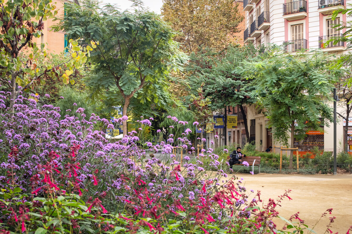
The Jardí Illa (2023) by LANDLAB Laboratorio de paisajes
The Jardí Illa project, designed by the LANDLAB team, dates from the same year as the previous example, but was shaped by the unique circumstances of its location, at the intersection of Consell de Cent and Enric Granados. It is situated halfway between Plaça Letamendi and the University of Barcelona Gardens and thus helps to enhance a landscape axis of great historical and botanical interest, due to the diversity of species it harbors.
The space is organized with an asymmetrical design that alternates paths and irregularly shaped garden beds. The green elements are classified according to their function and characteristics into botanical gardens, with greater biodiversity; Mediterranean gardens, dominated by low-maintenance local species; and rain gardens, which play a more active role in restoring the natural water cycle.
In all cases, plant species have been chosen for their suitability to both the current and future environment, taking climate change into account. Species that may temporarily disappear or that bloom at different times have also been included, emphasizing the cycle of the seasons.
The project also incorporates solutions from the SUDS repertoire, such as tree pits, bioretention strips, floodable garden beds, and infiltration basins.
Jardí Illa in its urban context, © LANDLAB
Reinventing Cerdà’s Eixample Blocks
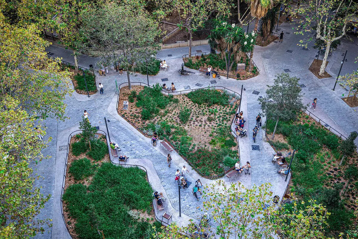
On another note, still linked to the legacy and evolution of the Eixample, it is worth recalling the labor of the municipal organization ProEixample, which, beginning in the 1980s, dedicated itself to revitalizing the neighborhood’s inner courtyards as parks and public spaces.
The spirit of this initiative sought to return to the origins of the Cerdà Plan with its aspirations for a garden city and was essentially aligned with more recent greening initiatives. Although the organization no longer exists, its legacy endures, and to date more than forty block centers have been converted, including the Montserrat Roig Gardens and the Cándida Pérez Gardens. The restoration process is somewhat slow and highly complex, but the results are very rewarding.
Jardins d’Interior d’Illa Càndida Pérez by RCR Arquitectes, © Vicente Zambrano González/Ajuntament de Barcelona, licensed under CC BY-NC-ND 4.0
The Isabel Vilà and Dolors Piera Plazas (2020) by the Institut Municipal d’Urbanisme
Although it is a rather unique case, the squares Isabel Vilà and Dolors Piera represent a variation on the interventions mentioned above. They are located on a block laid out according to the Cerdà Plan, but situated in the Poblenou neighborhood.
The partial and delayed development of the block allowed for a more comprehensive intervention within the framework of the 22@ project. New buildings were constructed on the flanks, and the public housing building by BAAS Arquitectura mentioned in the blog post “Social Housing in Barcelona’s Sant Martí District” was built in the center.
Once the building massing was redefined, an ambitious redevelopment of the open space was undertaken, resulting in what is known as the Isabel Vilà and Dolors Piera Plazas (2020), designed by the Municipal Institute of Urban Planning. Rather than squares in the traditional sense, these are two interconnected parks strongly linked to the surrounding streets through the opening of the chamfers.
As in other recent projects, the successful design of these spaces is largely based on the application of SUDS, notably the use of permeable paving and a series of ponds and wells designed to collect and reuse rainwater.
The proposal also includes paths, varying elevations, a long pergola with benches, urban vegetable patches, and lush vegetation that help create a small oasis in the heart of 22@.
Aerial view of Plaça de les Glòries in 2006, © Tavisa/Ajuntament de Barcelona, licensed under CC BY-NC-ND 4.0
The Plaça de Les Glòries: From a Failed Civic Epicenter to a Major Crossroads
One of the most emblematic examples of urban planning and landscaping in the new Barcelona is the Parc de les Glòries, and to understand its significance, a brief overview of the history of this space may prove enlightening.
As part of the Eixample project, Ildefons Cerdà conceived a plaza shaped like a tilted square at this strategic location where three major avenues intersected, destined to become the new symbolic and political center of Barcelona. But relocating the institutions to this site far from the historic city center, in an area that would take decades to develop, required an immense effort and a political will that no one was willing to assume.
By the time the city finally reached this area, the Plaça de les Glòries had become a residual space where vehicular traffic had taken over, although a few disconnected gardens had managed to squeeze in between the avenues and viaducts.
On the occasion of the 1992 Olympic Games, an attempt was made to bring order to this chaotic space that did little to live up to its name (Plaza of the Glories). An elevated elliptical viaduct was then built, which proved beneficial from the standpoint of traffic flow but left much to be desired from the perspective of pedestrians. The pseudo-square remained a barrier between the different neighborhoods that converged at this crossroads.
Aerial view of the redesigned Plaça de les Glòries in 2025, © DRONEIT/Ajuntament de Barcelona, licensed under CC BY-NC-ND 4.0
The Parc de les Glòries (2025) by Agence Ter and Ana Coello
Finally, around the year 2000, the City Council determined that a new project was necessary, but with a very different goal: rather than improving traffic flow, the aim would be to restore the urban fabric and renaturalize the public space. The relative scarcity of large green spaces in the city further tipped the scales towards this option: Les Glòries would be renovated as an urban park.
An international competition was then launched to transform this traffic hub into a predominantly green and pedestrian-friendly space. The results were announced in 2014, with first prize awarded to the team formed by Agence Ter and Ana Coello de Llobet. The proposal was radical in many respects, but due to various logistical circumstances, would not be completed until more than a decade later, in 2025.
Canòpia Urbana – Parc de les Glòries by Agence Ter and Ana Coello, © Fernando Lua
The first thing that catches the eye about the project is the solution adopted for the existing avenues. Both the Diagonal and the Meridiana avenues are completely closed to car traffic, serving solely as thoroughfares for pedestrians and bicycles. Only the Gran Vía maintains its continuity thanks to the construction of an ambitious tunnel that had to pass under the two train lines and one subway line located beneath the plaza.
This decision was made due to the significance of this avenue, which extends even beyond the metropolitan area: to the southwest, it connects to the airport, and to the northeast, to the highway leading to France.
The effects of these decisions are more than evident. The Parc de Les Glòries is now a haven of calm, while also fostering the interconnection of the surrounding neighborhoods.
Children’s playground at Canòpia Urbana – Parc de les Glòries, © Fernando Lua
Biodiversity Nodes and the Gran Clariana
Another key aspect of the project was the creation of three distinct levels: an underground level devoted to services and transportation, a ground-level area for pedestrian use, and a third level defined as an “urban canopy,” formed by the tree tops.
In terms of landscape design, the park is structured around thematic nodes with biomorphic silhouettes, dedicated to topics such as sports, children’s playgrounds, dogs, and the promotion of biodiversity. Among these, the Gran Clariana (Great Clearing) stands out—a large expanse of grass that has quickly become a popular gathering spot for public leisure.
In the rest of the green areas, local tree species, shrubs, and plants with low water requirements predominate. The wild appearance of the garden beds reflects the goal of recreating microhabitats that encourage the proliferation of urban wildlife, and once again, SUDS strategies are integrated, helping to restore the natural water cycle.
Cactus garden at Canòpia Urbana – Parc de les Glòries, © Fernando Lua
Renaturalization as an Urban Planning Project for Barcelona
The scale of the undertaking at Parc de les Glòries ensures a positive and significant impact on the process of renaturalizing the urban environment, making it one of the most ambitious projects on the path toward a more sustainable, livable, and socially cohesive Barcelona.
However, its most notable value lies in the fact that it is not an isolated initiative, but rather part of a broader, coherent urban strategy that coordinates efforts of different scales under the same principles. The park synthesizes many of the strategies developed in smaller-scale projects: the expansion of pedestrian space, the incorporation of sustainable drainage systems, the promotion of biodiversity, and adaptation to climate change.
Both the new garden squares in the Eixample and the revitalized inner courtyards, the Green Axes, and the large metropolitan parks form part of an interconnected network that reinforces the city’s resilience and livability.
This comprehensive approach multiplies the impact of each intervention and redefines Barcelona’s urban image, fostering a new dynamic between citizens, public space, and nature.
Text: Pedro Capriata
BIBLIOGRAPHY
08014 Arquitectura (s.f.). Plaça-Jardí Rocafort.
https://www.estudi08014.com/wordpress/?page_id=3993
ACPA Ana Coello (s.f.). Parque de las Glorias canopia urbana.
https://acpa.com.es/es/proyectos/parque-de-las-glorias-canopia-urbana/
Ajuntament de Barcelona (2018). Urbanització a la Plaça Dolors Piera i la Plaça Isabel Vila.
https://ajuntament.barcelona.cat/santmarti/sites/default/files/plenari/fitxers/urbanitzacio_pl._dolors_piera.pdf
Ajuntament de Barcelona (2021). Guia Tècnica per al disseny de sistemas de drenatge urbà sostenible.
https://share.google/rXwfQ6CXfzm6a8rq5
Ajuntament de Barcelona (2021). Pla Natura Barcelona 2021-2030.
https://share.google/BjbNIzFKnAlB5zkk5
Batlleiroig (2022). Fusionando Ciudad y Naturaleza. Actar.
Capriata, P. (2023). Las Supermanzanas y los ejes verdes de Barcelona, un modelo de ciudad más sostenible. Guiding Architects Barcelona.
https://www.gabarcelona.com/es/blog/supermanzanas/
Capriata, P. (2025). Vivienda social en el distrito de Sant Martí de Barcelona. Guiding Architects Barcelona.
https://www.gabarcelona.com/es/blog/vivienda-social-barcelona-sant-marti/
Capriata, P. (2026). Proyectos de renaturalización urbana en Barcelona I. Guiding Architects Barcelona.
https://www.gabarcelona.com/es/blog/proyectos-renaturalizacion-urbana-barcelona-i/
Centre Obert d’Arquitectura (s.f.). ArquitecturaCatalana.Cat
https://www.arquitecturacatalana.cat/es
Cot, G. (2025). Plaça Dolors Piera I Plaça Isabel Vilà – Districte 22@. Behance.
https://www.behance.net/gallery/228129349/Placa-Dolors-Piera-I-Placa-Isabel-Vila-Districte-22?tracking_source=search_projects%7CPobleNou&l=15
Gehl, J. (2006). La humanización del espacio urbano. Editorial Reverté.
Gkoltsioufla, K. (2022). Reconnecting with nature: Landscape Architecture and Nature based solutions. IFLA Europe.
https://share.google/VxDlexqhnITBmJQE3
Jacobs, J. (2011). Muerte y vida de las grandes ciudades. Capitán Swing Libros.
Landezine (s.f.). Plaza Enric Grandos (Jardí Illa).
https://landezine.com/plaza-enric-grandos-jardi-illa-by-landlab-laboratorio-de-paisajes
Pujalte, S. (2021). Plan Natura Barcelona, hacia un 2030 más verde. Spanish-architects.com.
https://spanish-architects.com/es/architecture-news/destacados/plan-natura-barcelona-hacia-un-2030-mas-verde
Rueda, S. (2017). Ecosystemic urbanism: a way to make cities more sustainable. Barcelona Metròpolis, Num 102.
https://www.barcelona.cat/metropolis/sites/default/files/revistes/bm102baixa.pdf
Related Posts
16.06.2026
Several Projects Located in Barcelona Have Been Selected as Finalists for the FAD Architecture Awards.
23.03.2026
Barcelona Is Committed to Repurposing Roads and Paved Urban Spaces to Increase Green Surface and Prioritize Pedestrians.
16.02.2026
Barcelona, World Capital of Architecture, Kicks off a Unique Year – And We Invite You to Experience the City With Us.
19.01.2026
Exhibitions, Academic Events, Projections and Concerts Will Fill Barcelona to Commemorate the Centenary of Antoni Gaudí’s Death.