Ildefons Cerdà’s Eixample Plan
The Urban Development Project That Defined Barcelona’s Identity
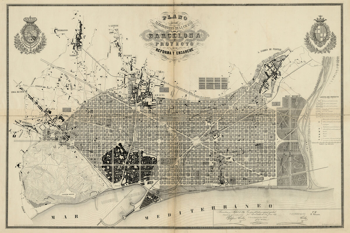
Original plan for Cerdà’s Eixample, Ildefons Cerdà i Sunyer – Museu d’Historia de la Ciutat
The Development of Barcelona Between 1700 and 1850
After undergoing a major transformation during the Middle Ages, Barcelona entered a period of apparent stability, marked by very gradual changes. It was not until the early 18th century that the city would once again embark on a more intensive process of evolution, which would have two key moments.
The first occurred in the years following the War of the Spanish Succession (1701–1714). As is well known, Catalonia allied itself with the Habsburgs, and as the last city on the peninsula to fall into the hands of the Bourbons, it became a target of the new dynasty’s hostility.
The New Plan Decrees (Decretos de Nueva Planta) included a series of repressive measures, such as the eradication of the institutional use of Catalan and the abolition of long-standing political and educational institutions. However, the most obvious consequence of the defeat was the construction of the Ciutadella, a fortification designed not to protect the city but to keep it under control. To make room for the Ciutadella, it was necessary to demolish more than a thousand buildings, which resulted in the reconfiguration of the entire La Ribera neighborhood and caused severe trauma to the citizens.
However, this adverse situation had a consequence that, in the long run, could even be viewed as positive. The Treaty of Utrecht, which brought the war to an end, left the Spanish Empire without its two major textile centers: Flanders and Milan. In this context, Catalonia significantly increased its textile production to compensate for this loss, and it is worth noting that textile manufacturing was closely linked to the process of industrialization in the decades that followed.
Thus, from the early 19th century onward, Barcelona began to host mechanized textile factories, which had consequences at every level: economic transformation, population growth due to internal migration, and a rapid deterioration of urban living conditions.
As part of the restrictions imposed in the New Plan Decrees, the city was prohibited from expanding beyond its archaic walls, and new residents crowded into the city as best they could, simultaneously increasing Barcelona’s population density and unsanitary conditions. The city became filled with taller buildings—less well-lit and ventilated, subdivided into smaller units—constrained by an urban layout that was clearly obsolete.
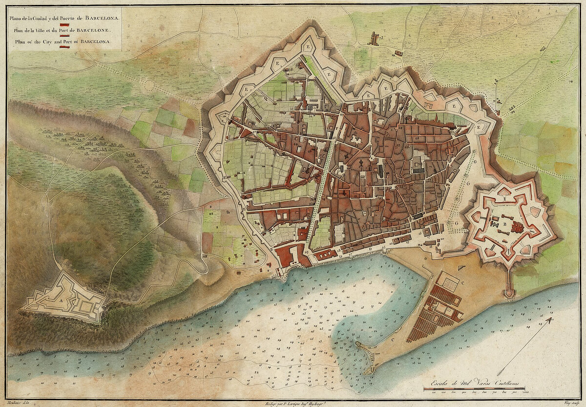
Walled city and citadel, Plan of the City and Port of Barcelona, 1806
The Need to Expand an Industrialized City
By the mid-19th century, the situation in Barcelona had become unsustainable due to industrial growth, population pressure, and poor sanitary conditions that fostered the spread of disease. Although the need to tear down the city walls and expand the city had been evident for years, it was necessary to wait for a favorable political moment—which arrived in 1854—for authorization to be granted from Madrid. State approval to demolish the Ciutadella, however—a technical necessity but above all a popular demand—did not come until 1868. Disagreements over the next steps toward modernization persisted, however.
In 1859 the City Council held a competition for the city’s expansion, which was won by architect Antoni Rovira i Trias. His proposal was highly commendable and aligned with the prevailing trends of mid-19th-century bourgeois urban planning, exemplified by Baron Haussmann’s reforms in Paris and Ludwig Förster’s Ringstraße in Vienna. It proposed a hierarchical layout, with a central square at the edge of the historic city that served as the hub for a network of concentric boulevards connecting to neighboring municipalities.
At the same time, engineer Ildefons Cerdà—who in 1855 had been commissioned by Madrid to conduct a topographic survey of the Barcelona plain—had submitted his own proposal for the city’s expansion. The central government was impressed by Cerdà’s plan and decided to enforce its implementation, sparking significant technical—but above all political—controversy as the imposition came into direct conflict with the City Council.
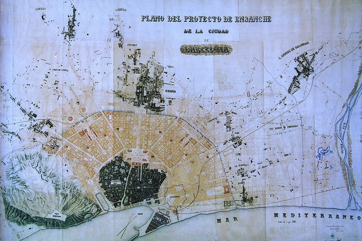
Winning plan from the 1859 municipal competition, Antoni Rovira i Trias – Museu d’Historia de la Ciutat
The Implementation of the Cerdà Plan
Setting aside the controversies and the merits of the Rovira i Trias Plan, the fact is that Ildefons Cerdà’s project was based on a more comprehensive conception of the city, understood not simply as a collection of buildings, but as an interconnected functional system of housing, services, roads, and public space. Furthermore, it entailed a more egalitarian approach with a greater emphasis on public health, in contrast to Rovira’s proposal, which was more conservative and potentially more profitable for private real estate development.
These principles were embodied in an orthogonal grid aligned with the layout of Roman Barcino, which could be a coincidence, but it seems clear that both Cerdà and the Romans based their orientation on the local geography, the winds, and the sun’s path.
The proposed grid covered an area unimaginable at the time, stretching from Montjuïc to the Besòs River and from the Mediterranean to the Collserola mountain range. The planned width of the streets was 20 meters, but the plan was complemented by wider, more prominent boulevard-style avenues, such as the Diagonal, the Gran Vía, and the Meridiana.
These three axes converged at the Plaça de les Glòries Catalanes, conceived by Cerdà as the city’s new administrative and symbolic center. The distance from the established city and the lack of transportation left the hypothetical civic square sidelined; instead, the City Council insisted on formalizing Plaça Catalunya, an undeveloped space linking the old city with the new one, which citizens spontaneously used as a gathering place.
It also coincided with the main square proposed by Rovira i Trias, but it was not included in Cerdà’s plan. Although the municipal initiative dated back to 1862, the central government did not authorize the formal development of the square until 1889.
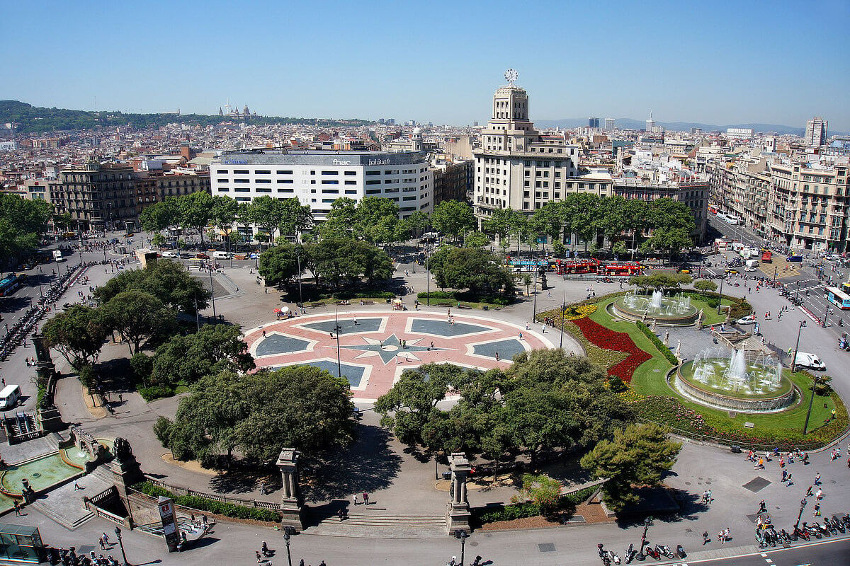
Plaça Catalunya, © Vicente Zambrano González – Ajuntament de Barcelona, licensed under CC BY-NC-ND 4.0
Densification and Redevelopment of the Eixample
As for the city blocks, the standard unit in the Eixample was a square with sides measuring 113 m cut at 14 m from each corner to create four chamfers, designed to facilitate turns and improve traffic flow. Buildings were permitted only along two sides of the block, with a ground floor plus three stories and a depth of 20m; the rest of the block was left as green space or open area. With this layout, Cerdà clearly aligned himself with hygienist ideals, ensuring natural light, sunlight, and ventilation for all buildings, while also setting a precedent for the garden city concept, formulated in 1898 by Ebenezer Howard.
However, this initial configuration underwent rapid changes. By the time the plan became a bylaw, Cerdà had modified the allowable building depth to 28 m. In 1862, the City Council permitted the construction of three building fronts with structures consisting of a ground floor plus four stories, and by 1891, the arrangement was formalized to include four building fronts, with an additional story and the ground-floor occupancy of the center of the block.
Little remained of the garden-city prototype, but the Cerdà plan demonstrated surprising resilience, and many essential aspects were preserved even amid the regulatory changes that ultimately defined the density and character of the Eixample, creating a distinctive identity for Barcelona.
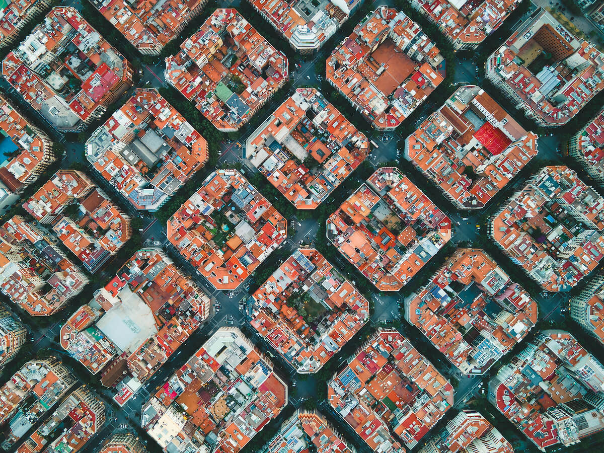
Aerial view of the Eixample, © Florian Schmidt – Unsplash
The Eixample as a Setting for Modernism
Toward the end of the 19th century, the Eixample became a fertile ground for the development of Modernismo thanks to its wide streets and the absence of historic buildings. The new style emerged as an architectural expression of the Renaixença, which asserted Catalan identity in contrast to Spain as a whole, while also establishing itself as a representation of a bourgeoisie that had risen socially through industry and commerce and identified with the new city.
Modernista facades proliferated throughout the Eixample and helped position Barcelona as a modern and cosmopolitan city, connected to the international Art Nouveau movement. Cerdà’s aspirations for equity were thus undermined by this proliferation of luxury buildings, which also seemed to compete with one another.
The most emblematic example is found in the “Block of Discord,” where the three most celebrated architects of their time each transformed pre-existing buildings. Puig i Cadafalch, Domènech i Montaner, and Antoni Gaudí created three of their masterpieces here—Casa Amatller (1900), Casa Lleó Morera (1905), and Casa Batlló (1906)—demonstrating the full creative potential of Modernismo, its possible variations, and its interaction with the urban environment.
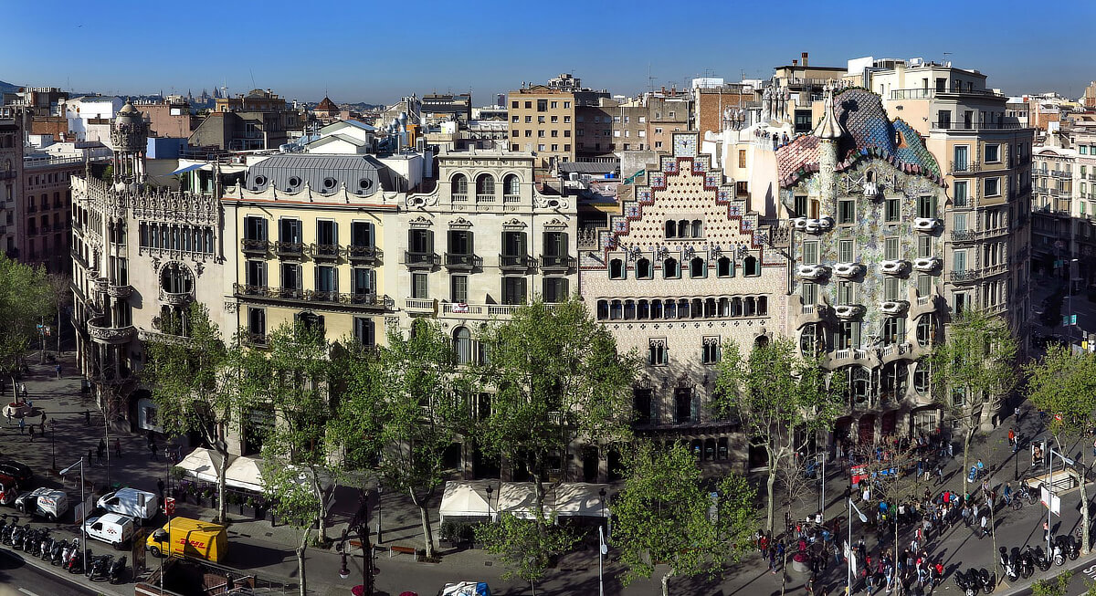
Manzana de la Discordia (Block of Discord), © Vicente Zambrano González – Ajuntament de Barcelona, licensed under CC BY-NC-ND 4.0
The Expansion, Consolidation, and Transformation of the Eixample in the 20th Century
As part of its expansion, Barcelona annexed the surrounding towns, and the Eixample project partially overlapped with existing urban layouts, losing what little orthodoxy it had left but once again demonstrating its potential flexibility. This was particularly evident in the Poblenou neighborhood, where, in addition to pre-existing roads and streets, numerous industrial facilities had been established that did not conform to the grid pattern. The area adjacent to Pere IV Street is clearly perceived as an anomaly and highlights this overlap of street layouts.
In fact, one of the objectives of the 1907 Jaussely Plan was precisely to integrate the Eixample with the surrounding towns of Barcelona. Although it was never implemented, it should be noted that in other respects this urban planning proposal entailed a return to an ideal of a monumental and hierarchical city.
For very different reasons, the 1934 Macià Plan met the same fate; conceived by the rationalist architects of the Grup d’Arquitectes i Tècnics Catalans per al Progrés de l’Arquitectura Contemporànea (GATPAC), it retained certain aspects of the Cerdà Plan within the framework of a functionalist reorganization.
In the years leading up to the 1992 Olympic Games, the Eixample district returned to the forefront of urban planning discussions when the MBM Arquitectes team used it as a model for their Olympic Village proposal. Once again, the Cerdà Plan demonstrated that it could be adapted and reinterpreted in different contexts. Oriol Bohigas and his team modified the layout of a declining industrial area to transform it into a residential neighborhood with an underlying grid and landscaped inner courtyards. The success of the project was linked to Barcelona’s reconnection with the Mediterranean through the Olympic Port, but the connection to Cerdà’s proposals did not go unnoticed, highlighting his influence more than a century after his plan had been conceived.
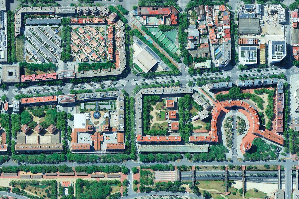
Reinterpretation and adaptation of the Eixample grid in the Vila Olímpica, © Google Earth
Cerdà’s Legacy: The Eixample Today
The enduring legacy of Cerdà has little to do with the exhaustive implementation of his ideas or his original plan. On the contrary, it is closely linked to the resilience of his plan to survive a succession of modifications and adaptations, including the considerable densification of the Eixample. It also has much to do with its effectiveness in creating a unique urban environment characterized by its scale and regular layout, and especially by the chamfers, which have become defining features of the city.
Whether or not they count it among their direct sources of inspiration, contemporary urban planners and architects typically continue to take the Cerdà Plan into account when designing in Barcelona. In fact, the most interesting urban proposals in the city over the past few decades are, in a way, reinterpretations of the Eixample, such as the Superblocks or the Green Axes. Both approaches, which are closely linked, have the potential to be applied to other cities, but both their conception and implementation make the most sense in the context of Barcelona and Cerdà’s grid. In both cases, the aim is to make the most of the width of the streets, but above all of the intersections, as evidenced by the projects discussed in a recent Guiding Architects article on renaturalization.
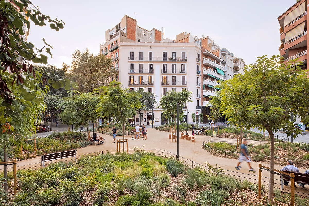
Plaça-jardí Rocafort by 08014 arquitectura, © Pol Viladoms
Another project that builds on Cerdà’s ideas is the Glòries Park (2025. Although it departs from the civic character he envisioned for this intersection, it aligns with his aspiration to create a greener city, featuring large urban parks.
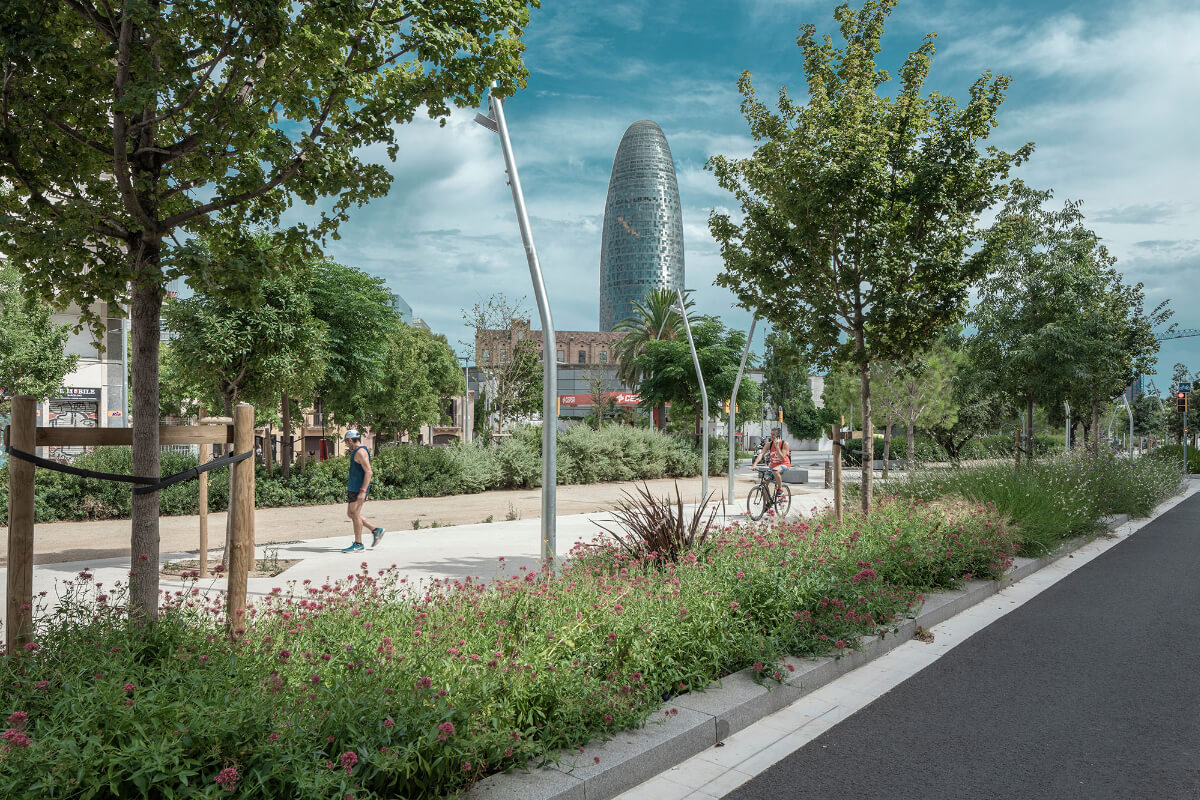
Finally, we cannot fail to mention the 22@ innovation district. With the goal of revitalizing a declining industrial neighborhood, the 22@ is transforming parts of the Poblenou into a mixed-use district featuring offices for technology companies. As mentioned earlier, the layout of this neighborhood is the result of superimposing Cerdà’s grid onto existing streets, and the new interventions seek to make the most of these conditions by modifying occupancy parameters, redesigning block centers, expanding pedestrian areas, and, in general, improving public space in the district.
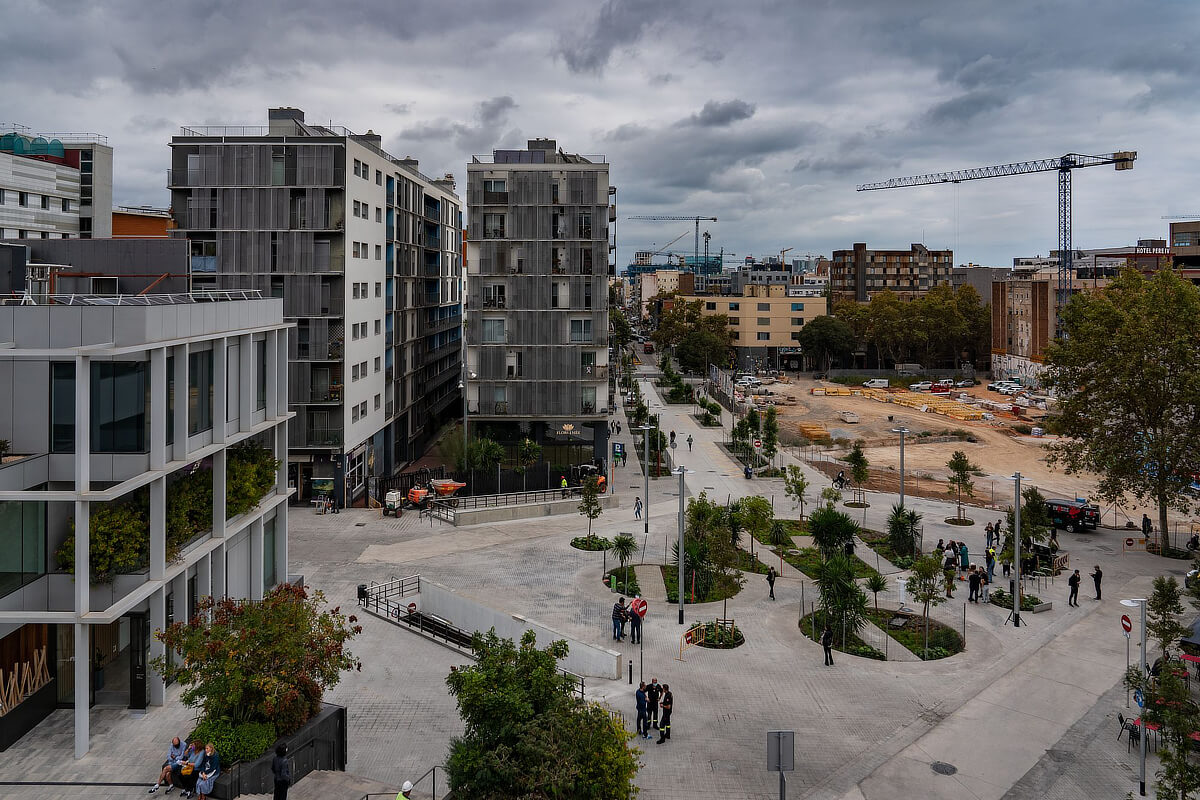
New Almogàvers-Zamora green axis in 22@, Laura Guerrero – Ajuntament de Barcelona, licensed under CC BY-NC-ND 4.0
The genius of Ildefons Cerdà and his Eixample lies in having created an urban planning model capable of adapting to a wide range of constraints over time, while maintaining a structural coherence and a distinct character that continues to influence contemporary designers.
Text: Pedro Capriata
BIBLIOGRAPHY
Bonet Correa, A. (2009). Barcelona moderna: Realidad y utopía del Plan Cerdà. Sociedad Estatal de Conmemoraciones Culturales.
Busquets, J. (2004). Barcelona. La construcción urbanística de una ciudad compacta. Ediciones del Serbal.
Centre Obert d’Arquitectura (s.f.). ArquitecturaCatalana.Cat
https://www.arquitecturacatalana.cat/es
Cerdà, I. (1991). Teoría de la construcción de las ciudades, vol. 1 y 2. Ministerio de Administraciones Públicas. (Obra original publicada en 1859 y 1861).
Cerdà, I. (1971). Teoría general de la urbanización y aplicación de sus principios y doctrinas a la reforma y ensanche de Barcelona. Instituto de Estudios Fiscales. (Obra original publicada en 1867).
Frampton, K. (1992). Modern Architecture. A Critical History. Thames and Hudson.
Gupo 2C (2009). La Barcelona de Cerdà. Flor del Viento.
Hughes, R. (2006). Barcelona. Anagrama.
López, M. Ed. (2010). Cerdà y Barcelona: La primera metrópoli, 1853-1897. Museu d’Història de Barcelona
Magrinyà, F. (2017). Cerdà: 150 años de modernidad. Actar
Magrinyà, F. (¿) Teoría Cerdà. Universitat Politècnica de Catalunya.
Permanyer, L. (2008). L’Eixample: 150 anys d’història. Ajuntament de Barcelona.
Rueda, S. (2020). Regenerando el Plan Cerdà: de la manzana de Cerdà a la supermanzana. Agbbar.
Solà-Morales, M. (2009). Deu Lliçons sobre Barcelona. Col·legi d’Arquitectes de Catalunya.
Solà-Morales, M. (2010). Cerdà: Ensanche. Universitat Politècnica de Catalunya.
 Barcelona World Capital of Architecture 2026: Join Us for the Second Half of Our Program of Tours and Debates
Ildefons Cerdà’s Eixample Plan
The Urban Development Project That Defined Barcelona’s Identity
Original plan for Cerdà’s Eixample, Ildefons Cerdà i Sunyer – Museu d’Historia de la Ciutat
The Development of Barcelona Between 1700 and 1850
After undergoing a major transformation during the Middle Ages, Barcelona entered a period of apparent stability, marked by very gradual changes. It was not until the early 18th century that the city would once again embark on a more intensive process of evolution, which would have two key moments.
The first occurred in the years following the War of the Spanish Succession (1701–1714). As is well known, Catalonia allied itself with the Habsburgs, and as the last city on the peninsula to fall into the hands of the Bourbons, it became a target of the new dynasty’s hostility.
The New Plan Decrees (Decretos de Nueva Planta) included a series of repressive measures, such as the eradication of the institutional use of Catalan and the abolition of long-standing political and educational institutions. However, the most obvious consequence of the defeat was the construction of the Ciutadella, a fortification designed not to protect the city but to keep it under control. To make room for the Ciutadella, it was necessary to demolish more than a thousand buildings, which resulted in the reconfiguration of the entire La Ribera neighborhood and caused severe trauma to the citizens.
However, this adverse situation had a consequence that, in the long run, could even be viewed as positive. The Treaty of Utrecht, which brought the war to an end, left the Spanish Empire without its two major textile centers: Flanders and Milan. In this context, Catalonia significantly increased its textile production to compensate for this loss, and it is worth noting that textile manufacturing was closely linked to the process of industrialization in the decades that followed.
Thus, from the early 19th century onward, Barcelona began to host mechanized textile factories, which had consequences at every level: economic transformation, population growth due to internal migration, and a rapid deterioration of urban living conditions.
As part of the restrictions imposed in the New Plan Decrees, the city was prohibited from expanding beyond its archaic walls, and new residents crowded into the city as best they could, simultaneously increasing Barcelona’s population density and unsanitary conditions. The city became filled with taller buildings—less well-lit and ventilated, subdivided into smaller units—constrained by an urban layout that was clearly obsolete.
Walled city and citadel, Plan of the City and Port of Barcelona, 1806
The Need to Expand an Industrialized City
By the mid-19th century, the situation in Barcelona had become unsustainable due to industrial growth, population pressure, and poor sanitary conditions that fostered the spread of disease. Although the need to tear down the city walls and expand the city had been evident for years, it was necessary to wait for a favorable political moment—which arrived in 1854—for authorization to be granted from Madrid. State approval to demolish the Ciutadella, however—a technical necessity but above all a popular demand—did not come until 1868. Disagreements over the next steps toward modernization persisted, however.
In 1859 the City Council held a competition for the city’s expansion, which was won by architect Antoni Rovira i Trias. His proposal was highly commendable and aligned with the prevailing trends of mid-19th-century bourgeois urban planning, exemplified by Baron Haussmann’s reforms in Paris and Ludwig Förster’s Ringstraße in Vienna. It proposed a hierarchical layout, with a central square at the edge of the historic city that served as the hub for a network of concentric boulevards connecting to neighboring municipalities.
At the same time, engineer Ildefons Cerdà—who in 1855 had been commissioned by Madrid to conduct a topographic survey of the Barcelona plain—had submitted his own proposal for the city’s expansion. The central government was impressed by Cerdà’s plan and decided to enforce its implementation, sparking significant technical—but above all political—controversy as the imposition came into direct conflict with the City Council.
Winning plan from the 1859 municipal competition, Antoni Rovira i Trias – Museu d’Historia de la Ciutat
The Implementation of the Cerdà Plan
Setting aside the controversies and the merits of the Rovira i Trias Plan, the fact is that Ildefons Cerdà’s project was based on a more comprehensive conception of the city, understood not simply as a collection of buildings, but as an interconnected functional system of housing, services, roads, and public space. Furthermore, it entailed a more egalitarian approach with a greater emphasis on public health, in contrast to Rovira’s proposal, which was more conservative and potentially more profitable for private real estate development.
These principles were embodied in an orthogonal grid aligned with the layout of Roman Barcino, which could be a coincidence, but it seems clear that both Cerdà and the Romans based their orientation on the local geography, the winds, and the sun’s path.
The proposed grid covered an area unimaginable at the time, stretching from Montjuïc to the Besòs River and from the Mediterranean to the Collserola mountain range. The planned width of the streets was 20 meters, but the plan was complemented by wider, more prominent boulevard-style avenues, such as the Diagonal, the Gran Vía, and the Meridiana.
These three axes converged at the Plaça de les Glòries Catalanes, conceived by Cerdà as the city’s new administrative and symbolic center. The distance from the established city and the lack of transportation left the hypothetical civic square sidelined; instead, the City Council insisted on formalizing Plaça Catalunya, an undeveloped space linking the old city with the new one, which citizens spontaneously used as a gathering place.
It also coincided with the main square proposed by Rovira i Trias, but it was not included in Cerdà’s plan. Although the municipal initiative dated back to 1862, the central government did not authorize the formal development of the square until 1889.
Plaça Catalunya, © Vicente Zambrano González – Ajuntament de Barcelona, licensed under CC BY-NC-ND 4.0
Densification and Redevelopment of the Eixample
As for the city blocks, the standard unit in the Eixample was a square with sides measuring 113 m cut at 14 m from each corner to create four chamfers, designed to facilitate turns and improve traffic flow. Buildings were permitted only along two sides of the block, with a ground floor plus three stories and a depth of 20m; the rest of the block was left as green space or open area. With this layout, Cerdà clearly aligned himself with hygienist ideals, ensuring natural light, sunlight, and ventilation for all buildings, while also setting a precedent for the garden city concept, formulated in 1898 by Ebenezer Howard.
However, this initial configuration underwent rapid changes. By the time the plan became a bylaw, Cerdà had modified the allowable building depth to 28 m. In 1862, the City Council permitted the construction of three building fronts with structures consisting of a ground floor plus four stories, and by 1891, the arrangement was formalized to include four building fronts, with an additional story and the ground-floor occupancy of the center of the block.
Little remained of the garden-city prototype, but the Cerdà plan demonstrated surprising resilience, and many essential aspects were preserved even amid the regulatory changes that ultimately defined the density and character of the Eixample, creating a distinctive identity for Barcelona.
Aerial view of the Eixample, © Florian Schmidt – Unsplash
The Eixample as a Setting for Modernism
Toward the end of the 19th century, the Eixample became a fertile ground for the development of Modernismo thanks to its wide streets and the absence of historic buildings. The new style emerged as an architectural expression of the Renaixença, which asserted Catalan identity in contrast to Spain as a whole, while also establishing itself as a representation of a bourgeoisie that had risen socially through industry and commerce and identified with the new city.
Modernista facades proliferated throughout the Eixample and helped position Barcelona as a modern and cosmopolitan city, connected to the international Art Nouveau movement. Cerdà’s aspirations for equity were thus undermined by this proliferation of luxury buildings, which also seemed to compete with one another.
The most emblematic example is found in the “Block of Discord,” where the three most celebrated architects of their time each transformed pre-existing buildings. Puig i Cadafalch, Domènech i Montaner, and Antoni Gaudí created three of their masterpieces here—Casa Amatller (1900), Casa Lleó Morera (1905), and Casa Batlló (1906)—demonstrating the full creative potential of Modernismo, its possible variations, and its interaction with the urban environment.
Manzana de la Discordia (Block of Discord), © Vicente Zambrano González – Ajuntament de Barcelona, licensed under CC BY-NC-ND 4.0
The Expansion, Consolidation, and Transformation of the Eixample in the 20th Century
As part of its expansion, Barcelona annexed the surrounding towns, and the Eixample project partially overlapped with existing urban layouts, losing what little orthodoxy it had left but once again demonstrating its potential flexibility. This was particularly evident in the Poblenou neighborhood, where, in addition to pre-existing roads and streets, numerous industrial facilities had been established that did not conform to the grid pattern. The area adjacent to Pere IV Street is clearly perceived as an anomaly and highlights this overlap of street layouts.
In fact, one of the objectives of the 1907 Jaussely Plan was precisely to integrate the Eixample with the surrounding towns of Barcelona. Although it was never implemented, it should be noted that in other respects this urban planning proposal entailed a return to an ideal of a monumental and hierarchical city.
For very different reasons, the 1934 Macià Plan met the same fate; conceived by the rationalist architects of the Grup d’Arquitectes i Tècnics Catalans per al Progrés de l’Arquitectura Contemporànea (GATPAC), it retained certain aspects of the Cerdà Plan within the framework of a functionalist reorganization.
In the years leading up to the 1992 Olympic Games, the Eixample district returned to the forefront of urban planning discussions when the MBM Arquitectes team used it as a model for their Olympic Village proposal. Once again, the Cerdà Plan demonstrated that it could be adapted and reinterpreted in different contexts. Oriol Bohigas and his team modified the layout of a declining industrial area to transform it into a residential neighborhood with an underlying grid and landscaped inner courtyards. The success of the project was linked to Barcelona’s reconnection with the Mediterranean through the Olympic Port, but the connection to Cerdà’s proposals did not go unnoticed, highlighting his influence more than a century after his plan had been conceived.
Reinterpretation and adaptation of the Eixample grid in the Vila Olímpica, © Google Earth
Cerdà’s Legacy: The Eixample Today
The enduring legacy of Cerdà has little to do with the exhaustive implementation of his ideas or his original plan. On the contrary, it is closely linked to the resilience of his plan to survive a succession of modifications and adaptations, including the considerable densification of the Eixample. It also has much to do with its effectiveness in creating a unique urban environment characterized by its scale and regular layout, and especially by the chamfers, which have become defining features of the city.
Whether or not they count it among their direct sources of inspiration, contemporary urban planners and architects typically continue to take the Cerdà Plan into account when designing in Barcelona. In fact, the most interesting urban proposals in the city over the past few decades are, in a way, reinterpretations of the Eixample, such as the Superblocks or the Green Axes. Both approaches, which are closely linked, have the potential to be applied to other cities, but both their conception and implementation make the most sense in the context of Barcelona and Cerdà’s grid. In both cases, the aim is to make the most of the width of the streets, but above all of the intersections, as evidenced by the projects discussed in a recent Guiding Architects article on renaturalization.
Plaça-jardí Rocafort by 08014 arquitectura, © Pol Viladoms
Another project that builds on Cerdà’s ideas is the Glòries Park (2025. Although it departs from the civic character he envisioned for this intersection, it aligns with his aspiration to create a greener city, featuring large urban parks.
Finally, we cannot fail to mention the 22@ innovation district. With the goal of revitalizing a declining industrial neighborhood, the 22@ is transforming parts of the Poblenou into a mixed-use district featuring offices for technology companies. As mentioned earlier, the layout of this neighborhood is the result of superimposing Cerdà’s grid onto existing streets, and the new interventions seek to make the most of these conditions by modifying occupancy parameters, redesigning block centers, expanding pedestrian areas, and, in general, improving public space in the district.
New Almogàvers-Zamora green axis in 22@, Laura Guerrero – Ajuntament de Barcelona, licensed under CC BY-NC-ND 4.0
The genius of Ildefons Cerdà and his Eixample lies in having created an urban planning model capable of adapting to a wide range of constraints over time, while maintaining a structural coherence and a distinct character that continues to influence contemporary designers.
Text: Pedro Capriata
BIBLIOGRAPHY
Bonet Correa, A. (2009). Barcelona moderna: Realidad y utopía del Plan Cerdà. Sociedad Estatal de Conmemoraciones Culturales.
Busquets, J. (2004). Barcelona. La construcción urbanística de una ciudad compacta. Ediciones del Serbal.
Centre Obert d’Arquitectura (s.f.). ArquitecturaCatalana.Cat
https://www.arquitecturacatalana.cat/es
Cerdà, I. (1991). Teoría de la construcción de las ciudades, vol. 1 y 2. Ministerio de Administraciones Públicas. (Obra original publicada en 1859 y 1861).
Cerdà, I. (1971). Teoría general de la urbanización y aplicación de sus principios y doctrinas a la reforma y ensanche de Barcelona. Instituto de Estudios Fiscales. (Obra original publicada en 1867).
Frampton, K. (1992). Modern Architecture. A Critical History. Thames and Hudson.
Gupo 2C (2009). La Barcelona de Cerdà. Flor del Viento.
Hughes, R. (2006). Barcelona. Anagrama.
López, M. Ed. (2010). Cerdà y Barcelona: La primera metrópoli, 1853-1897. Museu d’Història de Barcelona
Magrinyà, F. (2017). Cerdà: 150 años de modernidad. Actar
Magrinyà, F. (¿) Teoría Cerdà. Universitat Politècnica de Catalunya.
Permanyer, L. (2008). L’Eixample: 150 anys d’història. Ajuntament de Barcelona.
Rueda, S. (2020). Regenerando el Plan Cerdà: de la manzana de Cerdà a la supermanzana. Agbbar.
Solà-Morales, M. (2009). Deu Lliçons sobre Barcelona. Col·legi d’Arquitectes de Catalunya.
Solà-Morales, M. (2010). Cerdà: Ensanche. Universitat Politècnica de Catalunya.
Barcelona World Capital of Architecture 2026: Join Us for the Second Half of Our Program of Tours and DebatesRelated Posts
30.06.2026
From a Landmark Public Library to Industrial Heritage Sites and FAD Award-Recognised Works.
16.06.2026
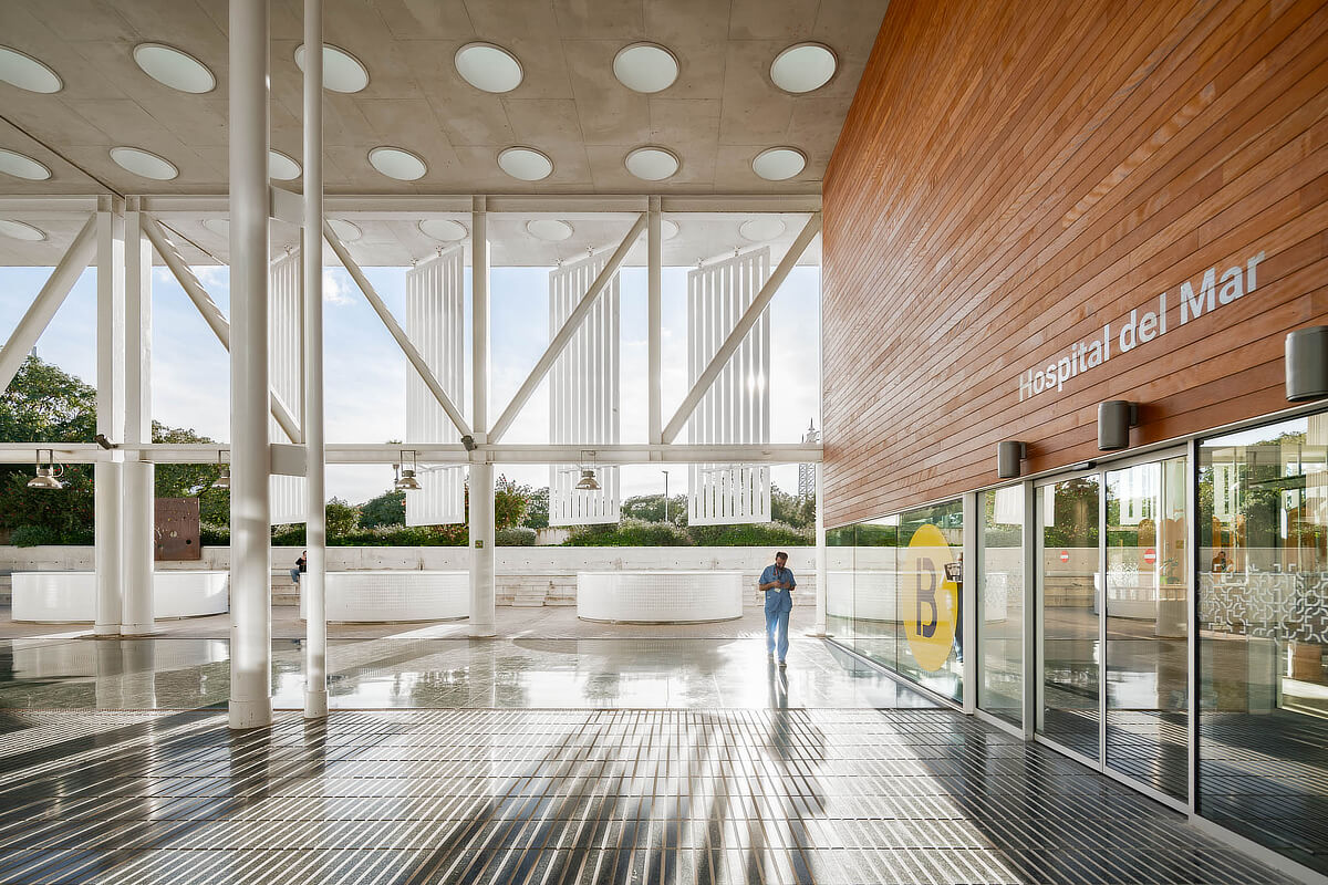
Several Projects Located in Barcelona Have Been Selected as Finalists for the FAD Architecture Awards.

11.05.2026
Barcelona Is Replacing Paved Areas Such as Intersections and Inner-Block Spaces With New Green Areas, Fostering Urban Ecological Regeneration.
23.03.2026
Barcelona Is Committed to Repurposing Roads and Paved Urban Spaces to Increase Green Surface and Prioritize Pedestrians.